The climb · Manitou Incline
The Manitou Incline, step by step
Under a mile long and about 2,000 feet high, the old railway bed above Ruxton Avenue is one of the steepest public climbs in the country, and the way down is a trail.
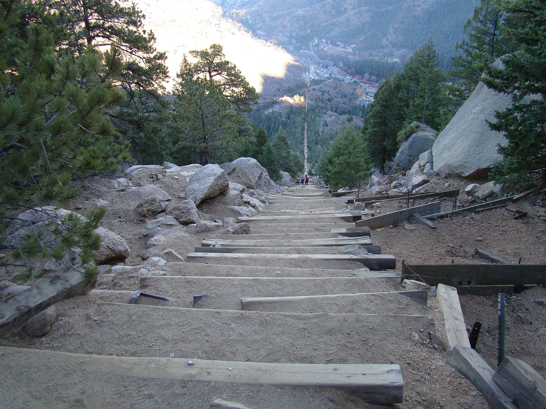
From the streets of Manitou Springs, look up at the mountain to the west and you will see it: a straight pale scar running almost vertically up through the pines. That line is the Manitou Incline, and it is exactly what it looks like. A staircase of old railway ties climbs about 2,000 feet in less than a mile, at an angle that in places is steeper than most ski runs.
The Incline is free to climb, it is brutal, and it is beloved. Local athletes use it as a training ground, visitors treat it as a test, and almost everyone who reaches the top spends the first few minutes bent over, breathing hard and staring back down at the town far below.
The top is a broad, rocky shoulder of the mountain at about 8,600 feet, with pines, boulders to sit on and a long view east over Manitou, the red rock country and the plains beyond. On clear mornings you can pick out the line of the Incline dropping away beneath your feet, which looks even steeper from above than it did from below. Take a few minutes there to rest, eat something and put on a layer before starting down, because the wind on the ridge cools a sweaty climber quickly.
A railway bed turned stairway
The Incline began as a working railway. In the early 1900s a cable railway was built straight up the mountainside to carry materials for water pipelines on the slopes above Manitou. Once that work was done, it carried sightseers instead, hauling cars up the steep grade to a viewpoint high above the town.
In 1990 a rockslide damaged the track, and the railway closed for good. The rails were pulled out, but the ties and the rough bed beneath them stayed, and people started climbing them. For years the climb sat in a legal grey area, crossing land with several owners. In 2013 it opened officially as a public trail, and over the following years crews rebuilt it, replacing loose ties, adding retaining walls and drainage, and making the route safer without taking the sting out of it.

The numbers behind the burn
The figures explain the reputation. The Incline gains roughly 2,000 feet over a little under a mile, which works out to an average grade of about 45 percent, with sections much steeper near the top. Most counts put the steps at around 2,700, and every one of them is a high step up onto a timber tie.
The bottom sits at about 6,600 feet and the top at about 8,600, so you are working hard in thin air from the very first step. Fit locals climb it in well under an hour. A first-timer from lower ground can expect it to take much longer, with plenty of stops. There is no shame in a slow climb. Go at a pace you can keep, rest when you need to, and step aside to let faster climbers pass.
There is no shame in a slow climb.
About two-thirds of the way up, a bailout path leads off to the side and joins Barr Trail. If your legs, lungs or the weather are telling you to stop, take it. Above the bailout comes the famous false summit: the steps seem to end, then you crest a rise and see another long, steep pitch still above you.
6,600 to 14,115 feetAnother stop on the mapPikes Peak by the cog railwayFree tickets, few parking spaces
The Incline is free to climb, but you need a reservation for a time slot, booked in advance through the city. The system was introduced to manage crowds, and its rules, opening hours and seasonal closures can change, so check the current arrangements before you go and bring your reservation with you.
Parking is the other puzzle. The base of the Incline sits at the top of Ruxton Avenue, a narrow residential street, and there is very little parking nearby. What there is fills quickly and is usually paid. At busy times the town has run a shuttle up Ruxton Avenue, but the arrangements vary from year to year. Many people park lower in town and walk up, passing the Iron Geyser on the way, which adds a warm-up of its own.
Down by Barr Trail, not the steps
Going back down the Incline itself is discouraged. The steps are steep, often loose, and crowded with people coming up, and a fall on the way down can be serious. Instead, from the top follow the signed connector across to Barr Trail and take it down.

Barr Trail switchbacks gently down through the forest for a few miles back to the trailhead near the base of the Incline. It is longer than the stairs but much easier on the knees, and the views out over Manitou and the plains open up on several corners. Allow at least an hour for the descent, and more if your legs are shaking from the climb.
The cog railway depot sits beside the base on Ruxton Avenue, so a climb on the Incline and a ride to the summit on another day share the same short walk from town.
Thin air, early starts and turning round
The Incline is short, but it is high and exposed. Visitors who arrived from sea level the day before often feel the altitude much more than they expected. If you can, spend a day or two in town first, and read up on altitude and afternoon storms before you go.
Start early. In summer, mornings are cooler and clearer, and thunderstorms often build over the mountains by early afternoon. The upper Incline is no place to be when lightning starts. Carry more water than you think you need, a snack, a warm layer and a light rain shell. In winter and early spring, the steps can be icy, and traction devices for your shoes make a real difference.
Above all, listen to your body. Dizziness, a pounding headache, nausea or chest pain are signs to stop, sit down and head down by the bailout or the way you came, slowly and carefully. Reaching the top matters far less than walking back into town afterwards.
Afterwards, the walk back down Ruxton Avenue is the easiest stretch of the day. Stop at the Iron Geyser for a taste of strongly mineral water, then carry on to the fountains along Manitou Avenue. Stretch your calves before you sit down for long, drink plenty of plain water through the evening, and expect stiff legs the next morning. Many people find the descent on Barr Trail harder on their thighs than the climb itself.

The pictures on this page were shared under open licences; see who took them.